How does the Interactive Mapping and Map Tools work?
The Interactive Mapping is available through the Property Report by clicking the map icon, and includes features such as google aerial imagery, property labels and property shading.
Open the Interactive Map
- Search for a Property Address to open the Property Report using the Quick Search function or search menu options
- Select the Map Icon or the Property Boundary Map located at the top of the property image.
- The Interactive Map will display and allow use of the Map Tools.
Using the Map Tools
Below is a summary of the Map Tools available through the Interactive Map and how to use them.
Property Shading
Property Shading allows you to highlight recent activity in the area such as sale price, sale date or current sale or rent listings.
- Under Map Layers select Property Shading
- Select the layers you wish to view
- Properties that match the criteria will load, with the colour key at the top of the map
Property Labels
Property Labels allow you to see information about either the current or all properties on your map such as the address, attributes, ownership, last sale or area.
- Under Map Layer select Property Label
- Select Current to only view your current property, or All for the labels to display across all properties
- Select the Labels you wish to view
View Other Properties
The Interactive Map also allows you to view the property card of nearby properties and click through to the property report. When the hand map tool is selected, click on a property to load the property card.
- Make sure the Hand Map Tool is selected
- Select on the map to load the Property Card for that address
- You can then either close the property card and continue to use the interactive map or select the address to load the property report
Area Tool
The Area Tool allows you to calculate the dimensions or area of a defined region
- Select the Ruler in the Map Tools
- Draw the search area by clicking on the map to set each point. As you move your mouse the area will expand.
- To complete the area double click your mouse at the last point. The dimensions and area will display.
- You can measure multiple regions by selecting the Ruler and adding an additional region/s or select the Trash Can to remove all regions.
Property Easements
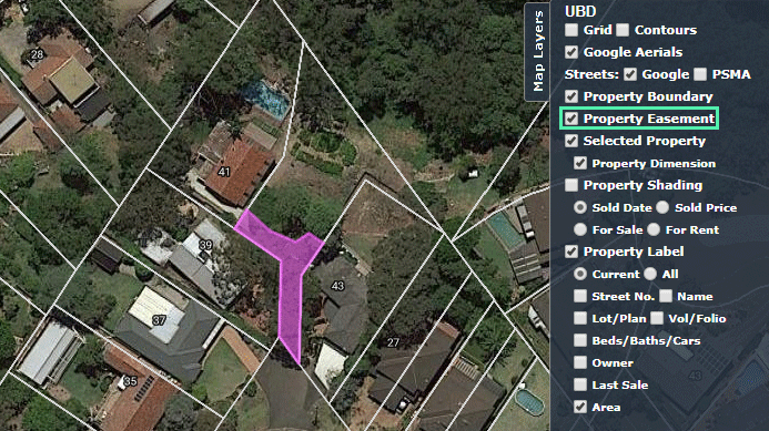
An easement is a section of land registered on a property title and provides 'the right to enter or use a section of land for a particular purpose by someone who is not the land owner'. An example is a shared driveway.
You can view Property Easements on the Interactive Map by selecting Property Easement under Map Layers. Property Easement's Appear on the Interactive Map as pink:
 Viewing Contour Layer
Contour lines join point of equal elevation above a given level (such as mean sea level) and show valleys and hills, and the steepness or gentleness of slopes on a map.
Pricefinder displays contours in red, and are labelled for every 25m of elevation. To enable contours select Contours under Map Layers.
Comments
Please sign in to leave a comment.